facebook icon linked_in icon youtube icon twitter icon instagram icon
Find a Dealer
CHC Worldwide
  • CHC Navigation - Corporate Headquarter
  • CHC Navigation Europe
  • CHC Navigation USA LLC
  • CHC Navigation India
English
  • Français
  • Español
chcnav logo
  • Industries
    • surveying-+and+-engineering
    • machine-control-+and+-construction
    • mapping-+and+-geospatial
    • infrastructure
    • marine-construction
    • precision-agriculture
    • navigation-+and+-positioning
  • Products
    • total-stations
    • gnss-systems
    • machine-control-solutions
    • mobile-mapping-systems
    • marine-systems
    • agriculture-systems
    • gnss-oem-systems
  • Support
    • Support and Training
    • Maintenance and Repair
  • About Us
    • Overview
    • News & Events
      • Latest News
      • Events
      • Press Releases
  • Contact Us
    • Send an Inquiry
    • Become a CHC Partner
    • Find a Dealer

CHC Navigation Introduces the D390 Echo Sounder

2020-04-02
https://chcnav.com/uploads/5e79a9e6/Product_banner_D390_bg.jpg
D390 Echo Sounder

FOR IMMEDIATE RELEASE


CHC Navigation Introduces the D390 Echo Sounder

A cost-effective bathymetric survey system.


Shanghai, China – March 30th, 2020 - CHC Navigation, today announced the availability of the D390 echo sounder system, a cost-effective and rugged bathymetric survey solution that uses an advanced 200 kHz transducer to match different hydrographic conditions and significantly improve sounding performance and usability.

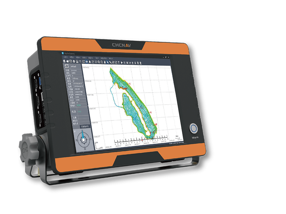
The D390 is a fully integrated and affordable single frequency echo sounder combined with the performance of an industrial PC. Light, portable and in a rugged IP66 aluminum alloy enclosure, the D390 is easy to set up and to deploy in any remote location. Its 12-inch touch screen display dramatically eases field survey operation making data always visible at a glance.

“The D390 echo sounder is a turnkey hydrographic solution, designed to simplified survey operation and cut down mission mobilization cost by 20%.” said George Zhao, CEO of CHC Navigation. “The D390 is a perfect add-on to our fast-growing Marine Construction Business Line.” he added.

The intuitive HydroSurvey 7 software manages bathymetric survey projects from positioning and navigation to data acquisition and data processing and export in CSV format for further post-processing with any 3rd party hydrographic software suite.


About CHC Navigation:

Founded in 2003, CHC Navigation is a publicly-listed company creating Innovative GNSS Navigation and Positioning Solutions. With a global presence across the world and distributors in over 100 countries and more than 1 300 employees, CHC Navigation is today recognized as one of the fastest-growing company in Geomatics Technologies.


###


For more information, please contact: marketing@chcnav.com


www.chcnav.com

e-Newsletter

Subscribe to our Newsletter and stay informed about exciting developments, new products, case studies and exclusive invitations to events.

captcha
I agree to the "Privacy Policy" and "Terms of use"
Please select this field to continue.
chcnav site logo
Contact Us

Phone:  

+86 21 5426 0273


Email:  

marketing@chcnav.com

Industries
  • Surveying & Engineering
  • Machine Control & Construction
  • Mapping & Geospatial
  • Infrastructure
  • Marine Construction
  • Precision Agriculture
  • Navigation & Positioning
Products
  • Total Stations
  • GNSS Systems
  • Machine Control Solutions
  • Mobile Mapping Systems
  • Marine Systems
  • Agriculture Systems
  • GNSS OEM Systems
Support
  • Support & Training
  • Maintenance & Repair
About Us
  • Overview
  • News & Events
Contact Us
  • Send an Inquiry
  • Become a CHCNAV Partner
  • Find a Dealer
© 2019 Shanghai Huace Navigation Technology Ltd.,All rights reserved.
Terms of Use | Privacy Policy | Cookies Policy
facebook icon linked_in icon youtube icon twitter icon instagram icon