CHCNAV Introduces CoPre: A Comprehensive Ecosystem for Optimized LiDAR and RGB Data Processing

.png)
Shanghai, China – January 12, 2023 - CHC Navigation (CHCNAV), a global leader in precision mapping solutions, announces the release of the latest version of CoPre, a software ecosystem designed to enhance the performance of CHCNAV's 3D reality capture solutions. Developed by CHCNAV, CoPre provides an end-to-end solution for rapid georeferencing, analysis, and modeling of high-quality 3D point cloud data captured by airborne, vehicle-based, and drone LiDAR scanners and imaging systems.
Jax Fu, Supervisor of the Mapping Product Line at CHC Navigation, commented, "CoPre addresses significant workflow bottlenecks in LiDAR processing. Its streamlined, automated workflows, robust quality checks, and powerful visualization capabilities empower geospatial professionals to realize the full potential of their mobile mapping data."
IMPROVE DATA PROCESSING WITH AUTOMATION
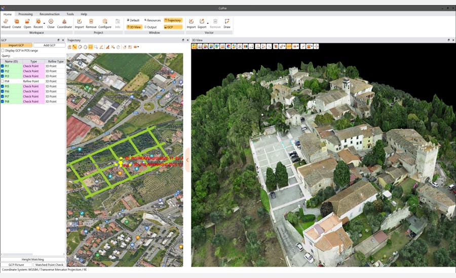
CoPre provides instant access to raw data from all CHCNAV airborne and terrestrial LiDAR solutions. Users can process data from the AlphaAir 10 compact airborne LiDAR system or the AlphaUni 20 for long-range corridor mapping projects. CoPre's user-friendly interface provides access to powerful LiDAR processing tools with a minimal learning curve, allowing users to perform essential processing steps such as point cloud processing, image georeferencing, and point cloud colorization with a single click.

Figure 1. The intuitive interface of the CoPre, a 3D laser scanning data processing software.
COMPREHENSIVE PREPROCESSING WORKFLOW
Trajectory generation is the first and pivotal step in LiDAR data processing. CoPre leverages CHCNAV's precise and efficient algorithms to process raw data, including trajectory (POS) files, LiDAR readings, and RGB images.
OPTIMIZED LIDAR DATA QUALITY
For advanced users, CoPre introduces an advanced calibration mode to improve data accuracy further. By addressing layering issues in multiple point clouds and improving relative accuracy through an efficient stripe adjustment algorithm, professionals can achieve point clouds that are 30% thinner compared to similar systems. Further absolute accuracy improvements can be achieved using ground control points.
ROBUST DATA INSPECTION AND VISUALIZATION
CoPre offers robust options for inspecting processed data and displaying large data sets in a variety of color options. It automatically detects and checks misalignments in all data and verifies elevation accuracy by importing control points with known elevations. CoPre also provides several reports to meet quality control requirements.
ADVANCED RECONSTRUCTION MODULE DOM GENERATION AND MODELING
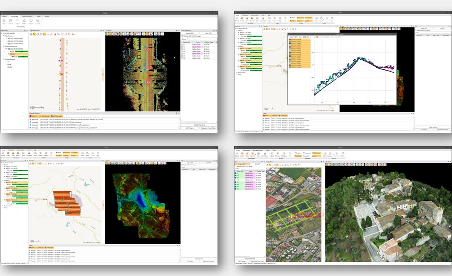
The CoPre Reconstruction module supports the aerial triangulation process, allowing users to export the final digital orthophoto and 3D mesh module output without the need for additional software. CoPre's DOM generation and modeling algorithm enables rapid export of high-quality orthophotos or 3D models by combining photos and point clouds simultaneously collected by CHCNAV LiDARs for in-field verification.

Figure 2. Georeferencing, trajectory processing, point cloud colorization, and digital ortho model (DOM) generation in CoPre software.
By consolidating complex LiDAR data operations into one intuitive platform, CoPre unlocks the full potential of 3D scanning and imaging workflows for professionals in transportation, urban modeling, mining, and other applications.
____
About CHC Navigation
CHC Navigation (CHCNAV) creates innovative mapping, navigation, and positioning solutions to make customers' work more efficient. CHCNAV products and solutions cover multiple industries such as geospatial, construction, agriculture, and marine. With a presence across the globe, distributors in more than 120 countries, and more than 1,700 employees, CHC Navigation is recognized as one of the fastest-growing companies in geomatics technologies today.
For more information about CHC Navigation [Huace:300627.SZ], please visit: https://chcnav.com/about-us/overview

