facebook icon linked_in icon youtube icon twitter icon instagram icon
Find a Dealer
CHC Worldwide
  • CHC Navigation - Corporate Headquarter
  • CHC Navigation Europe
  • CHC Navigation USA LLC
  • CHC Navigation India
English
  • Français
  • Español
chcnav logo
  • Industries
    • surveying-+and+-engineering
    • machine-control-+and+-construction
    • mapping-+and+-geospatial
    • infrastructure
    • marine-construction
    • precision-agriculture
    • navigation-+and+-positioning
  • Products
    • total-stations
    • gnss-systems
    • machine-control-solutions
    • mobile-mapping-systems
    • marine-systems
    • agriculture-systems
    • gnss-oem-systems
  • Support
    • Support and Training
    • Maintenance and Repair
  • About Us
    • Overview
    • News & Events
      • Latest News
      • Events
      • Press Releases
  • Contact Us
    • Send an Inquiry
    • Become a CHC Partner
    • Find a Dealer

CHCNAV Launches Groundbreaking Aerial Survey Cameras for Enhanced Aerial Photogrammetry

2023-06-07
https://chcnav.com/uploads/c5-c30-cameras-photogrammetric-applications.jpg
C5 & C30
the C5 and C30 aerial survey cameras that deliver aerial photogrammetry with unparalleled precision and efficiency

Shanghai, China – June 7, 2023 - CHC Navigation (CHCNAV), a global leader in geospatial solutions, introduces the C5 and C30 aerial survey cameras, delivering aerial photogrammetry with unparalleled precision and efficiency. These cutting-edge cameras offer seamless integration with unmanned aerial vehicles (UAVs) and deliver exceptional image quality, enabling professionals to unlock the full potential of aerial surveying.
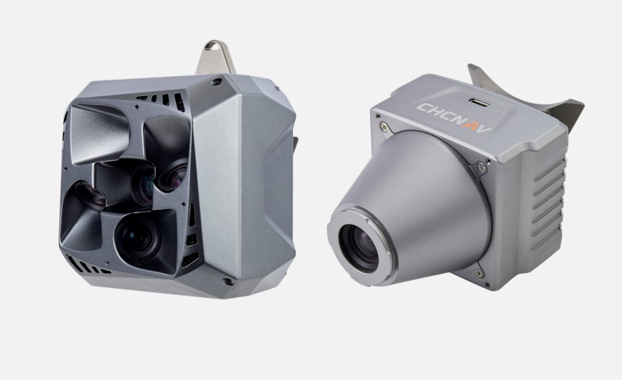
Figure 1. The C5 & C30 orthographic & oblique cameras for aerial surveys.


  • Unmatched Precision and Image Quality


The C5 and C30, aerial survey cameras, offer unparalleled image quality, capturing highly detailed and accurate aerial images. Professionals can rely on the cameras' advanced imaging technology to ensure that every pixel represents the area being surveyed with the utmost fidelity. This level of precision increases data accuracy and provides users with invaluable insights.
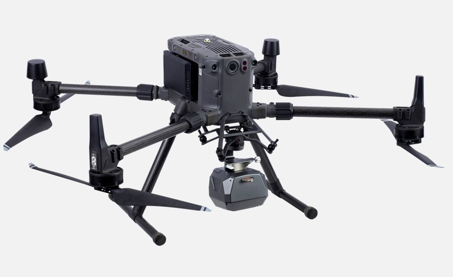
Figure 2. The C30 oblique camera that was installed on the DJI’s M300 UAV.


  • Seamless Integration and Versatile Applications


Designed for effortless integration with UAVs, the C5 and C30 cameras adapt to existing platforms, allowing professionals to optimize their workflow and achieve exceptional results. The versatility of these cameras opens the doors to a wide range of applications, including infrastructure planning, environmental monitoring, topographic mapping, and disaster management.
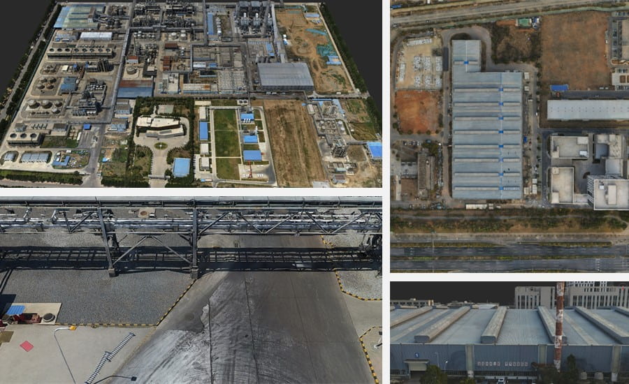
 

Figure 3. The aerial survey data that was collected by the C5 & C30 cameras.


  • Increased Efficiency with Advanced Photogrammetry


With the C5 and C30 cameras, CHCNAV introduces advanced photogrammetry capabilities that streamline data collection and processing. Professionals can efficiently plan missions, capture georeferenced images, and use easy-to-use software solutions to convert raw data into actionable insights.


___


About CHCNAV


CHC Navigation (CHCNAV) creates innovative GNSS navigation and positioning solutions to make customers' work more efficient. CHCNAV products and solutions cover multiple industries such as geospatial, construction, agriculture and marine. With a presence across the globe, distributors in more than 120 countries and more than 1,700 employees, today CHC Navigation is recognized as one of the fastest-growing companies in geomatics technologies.


For more information about CHC Navigation [Huace:300627.SZ], please visit: https://chcnav.com/about-us/overview 

e-Newsletter

Subscribe to our Newsletter and stay informed about exciting developments, new products, case studies and exclusive invitations to events.

captcha
I agree to the "Privacy Policy" and "Terms of use"
Please select this field to continue.
chcnav site logo
Contact Us

Phone:  

+86 21 5426 0273


Email:  

marketing@chcnav.com

Industries
  • Surveying & Engineering
  • Machine Control & Construction
  • Mapping & Geospatial
  • Infrastructure
  • Marine Construction
  • Precision Agriculture
  • Navigation & Positioning
Products
  • Total Stations
  • GNSS Systems
  • Machine Control Solutions
  • Mobile Mapping Systems
  • Marine Systems
  • Agriculture Systems
  • GNSS OEM Systems
Support
  • Support & Training
  • Maintenance & Repair
About Us
  • Overview
  • News & Events
Contact Us
  • Send an Inquiry
  • Become a CHCNAV Partner
  • Find a Dealer
© 2019 Shanghai Huace Navigation Technology Ltd.,All rights reserved.
Terms of Use | Privacy Policy | Cookies Policy
facebook icon linked_in icon youtube icon twitter icon instagram icon