Geospatial
Deliver accuracy to your geospatial projects with CHC Navigation.
Learn More + Go to Geospatial2025-02-28
Shanghai, China – February 28, 2025 – CHC Navigation (CHCNAV), a leader in geospatial technology and marine surveying solutions, has launched the HQ-400, a multibeam echosounder for bathymetric and hydrographic surveys. With a lightweight design and strong data acquisition capabilities, the HQ-400 provides reliable performance for underwater mapping and seafloor analysis in a compact form factor.
“The HQ-400 marks an important milestone in CHCNAV's marine surveying solutions. This compact multibeam echosounder provides high-resolution data for accurate and efficient seafloor mapping. With its versatile and user-friendly design, the HQ-400 brings advanced technology to hydrographic professionals in a compact package,” said Taxiya Wang, Product Manager at CHC Navigation.
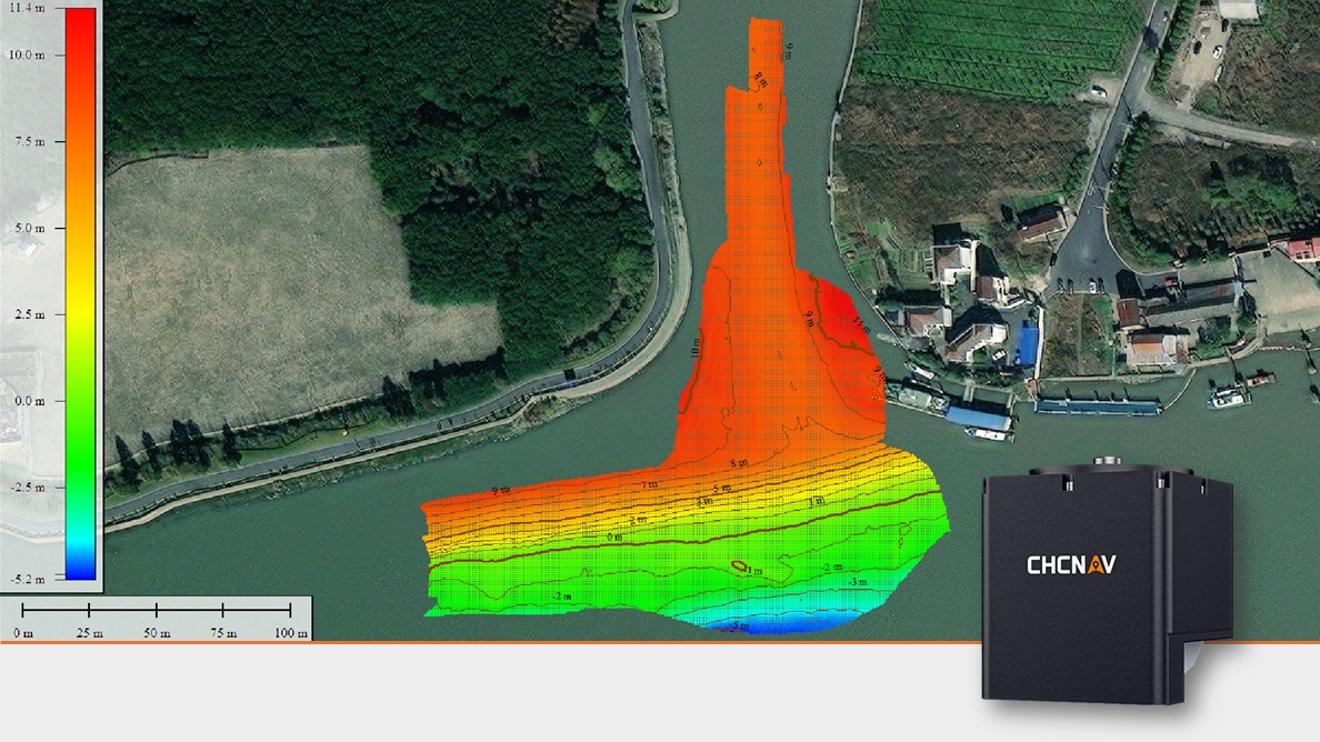
CHCNAV HQ-400 used in hydrographic survey for high-resolution seafloor mapping.
High-Resolution Survey Capabilities
The HQ-400 features 512 beams, digitally expanded to 1024, and offers a swath coverage of 140°, delivering centimeter-level resolution for underwater mapping and environmental monitoring. It supports a depth range of 0.2 m to 150 m, making it ideal for inland and coastal survey applications, including marine research, coastal engineering, underwater inspections, and habitat mapping.
Advanced Features for Optimal Performance
The HQ-400 offers real-time roll stabilization, side-scan imaging, and water column imaging to maintain consistent data quality in challenging conditions. Its pre-calibrated IMU (Inertial Measurement Unit) removes the need for field calibration, reducing setup time and increasing efficiency. Advanced signal processing algorithms further enhance the accuracy and reliability of the collected data.
Compact and Versatile Design
With dimensions of 12.5 cm per side and a weight of only 2.7 kg, the HQ-400 can be used on manned survey boats and unmanned surface vessels (USVs). It integrates sonar, temperature sensors, attitude sensors, positioning systems, and a compass into one unit, eliminating the need for additional devices and increasing operational flexibility. Its durable design ensures reliable performance in harsh water environments.
Comprehensive Software Ecosystem
CHCNAV provides a complete software suite for the HQ-400, including CMS for PC for data acquisition and post-processing, and EasySail for Android for real-time monitoring. The system is compatible with third-party software such as BeamworX and Hypack, offering users with flexibility for data processing, analysis, visualization, and reporting.
____
About CHC Navigation
CHC Navigation (CHCNAV) develops advanced mapping, navigation and positioning solutions designed to increase productivity and efficiency. Serving industries such as geospatial, agriculture, construction and autonomy, CHCNAV delivers innovative technologies that empower professionals and drive industry advancement. With a global presence spanning over 130 countries and a team of more than 1,900 professionals, CHC Navigation is recognized as a leader in the geospatial industry and beyond.To learn more about CHC Navigation [Huace:300627.SZ] and its solutions, please visit: https://chcnav.com/about/overview
Discover the HQ-400
a multibeam echosounder designed for precise and reliable underwater mapping.
