Geospatial
Deliver accuracy to your geospatial projects with CHC Navigation.
Learn More + Go to Geospatial2025-03-12
Shanghai, China – March 12, 2025 – CHC Navigation (CHCNAV), a global leader in navigation solutions, has launched the CGI-830, a GNSS/IMU Ground Truth System integrating tightly coupled GNSS and MEMS technology. This advanced system provides high-precision navigation for applications such as autonomous vehicles, ADAS testing, hydrographic surveying, and post-processed POS tasks in diverse environments, including urban, rural, and offshore areas.
“The CGI-830 is an ideal solution for industries that require precise positioning and attitude data,” said Daniel Yang, Product Manager at CHC Navigation. “Its integrated design, high-performance MEMS IMU, and adaptability across numerous applications make it an essential solution for enhancing operational efficiency and accuracy in both land and maritime environments.”
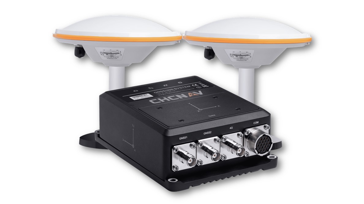
The CGI-830 Ground Truth System featuring tightly coupled GNSS and MEMS technology.
Tightly Coupled GNSS/INS Technology
The CGI-830 combines a multi-frequency GNSS module with a high-performance MEMS IMU featuring 0.1°/h bias instability. This tightly integrated system provides reliable positioning in challenging environments such as urban canyons, dense forests, mountainous terrain and underwater. It effectively mitigates multipath interference and signal obstructions, ensuring accurate positioning even in complex electromagnetic conditions and in applications such as smart cities and advanced robotics.
Versatile Connectivity and Rugged Design
The CGI-830 offers multiple connectivity options, including 4G, Wi-Fi, serial ports, Ethernet, and CAN. Its IP67-rated design and compliance with MIL-STD-810G standards ensure reliable performance in field applications such as construction, agriculture, and disaster response. Additionally, the system features an internal shock-absorbing structure that protects critical components, ensuring durability and consistent performance in demanding environments.
High-Frequency Data Output
With data output rates of up to 100 Hz, the CGI-830 meets the demands of dynamic applications, including unmanned aerial vehicles (UAVs), trains, ground vehicles, and marine vessels. Its dedicated post-processing software enhances the precision of 3D position, velocity, and attitude data, ensuring high performance for real-time navigation and mapping tasks.
Adaptable to Multiple Applications
The CGI-830 is designed to support a wide range of applications. Its onboard algorithms are optimized for diverse scenarios, including automotive operations, construction projects, and marine environments. With support for external odometers, DVL, and USBL, the CGI-830 delivers precise performance even in GNSS-denied environments, making it ideal for urban mobile mapping, infrastructure monitoring, geospatial analysis, and location-based services.
___
About CHC Navigation
CHC Navigation (CHCNAV) develops advanced mapping, navigation and positioning solutions designed to increase productivity and efficiency. Serving industries such as geospatial, agriculture, construction and autonomy, CHCNAV delivers innovative technologies that empower professionals and drive industry advancement. With a global presence spanning over 130 countries and a team of more than 1,900 professionals, CHC Navigation is recognized as a leader in the geospatial industry and beyond.To learn more about CHC Navigation [Huace:300627.SZ] and its solutions, please visit: https://chcnav.com/about/overview
Unlock the full potential of precision navigation with the CGI-830
